Overview
Navigation is the route-level layer of the SidewalkPilot autonomy stack. It answers "which way do I need to go to reach the destination" while the camera steering model answers "how do I follow the sidewalk that is directly in front of me." The two are deliberately kept separate: route planning runs over an explicit map graph so it can be inspected and explained, and local sidewalk-following stays inside the neural network where it belongs. Manual override and the LiDAR/AEB safety layer can interrupt either one at any time.
The whole navigation subsystem lives in one file,
code/controller/current/rc_car_app/navigation.py. It loads a pre-built map graph
(trossachs_nav_graph.json), reads the BN880 GPS over /dev/ttyAMA0 at 9600 baud,
snaps the car's start and the chosen destination onto sidewalk nodes, plans a path
with A*, and splits that path into alternating AI (sidewalk) and manual (crosswalk)
segments. On every control-loop tick, NavigationManager.update() re-localizes the
car to the nearest path node, computes remaining distance and ETA, and decides whether
the current segment should be driven by the model (AUTO) or handed to the human
(MNUL).
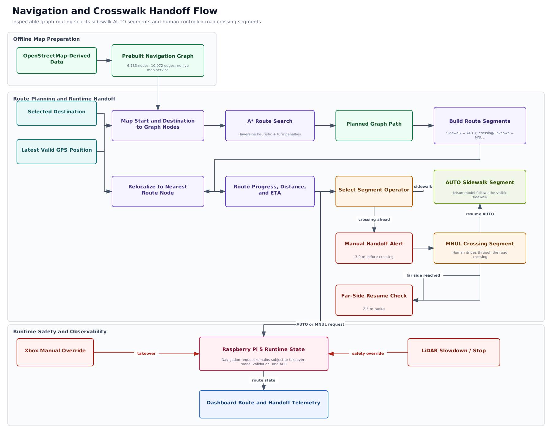
Navigation and crosswalk handoff flow. Open the full-size SVG or the editable draw.io source.
How It Works
NavigationManagerloads the graph on startup:6183nodes and10072edges of the Trossachs test neighborhood, keyed by uppercase 3-character IDs likeAAA.GpsReaderruns a background thread parsing$GPGGA/$GNGGANMEA sentences into lat/lon/fix/sats.- Each loop, the runtime calls
navigation.update(gps_state, odometer_m, speed_mps)and thennavigation.set_start_from_gps(...)so the route start always tracks the car's current position. - A* plans over the sidewalk/crosswalk graph with turn penalties, then the path is
cut into segments. Sidewalk segments are
mode="ai"/ operatorAUTO; crosswalk segments aremode="manual"/ operatorMNUL. - Handoff and resume geometry (a 3.0 m handoff alert before a crosswalk, a 2.5 m resume radius after it) drive the AI-to-manual transition at road crossings.
Graph and Endpoint Mapping
The checked-in JSON graph was built offline from OpenStreetMap data; the car does not need a live map service. It contains 6,183 nodes and 10,072 undirected edges. Nodes represent footways, houses, crosswalks, and steps. Edge kinds distinguish sidewalks, house access, crosswalks, intersections, transfers, and mapped gaps.
An entered house remains the displayed destination but is routed through its precomputed
stop_for_house sidewalk node. Other unsupported endpoints fall back to the nearest
sidewalk-compatible node. The offline graph builder creates house connectors; the runtime
does not solve address-to-sidewalk geometry while driving. A nearest-distance fallback can
select the wrong street, so arbitrary-address routing is not claimed.
A* Route Search
A* uses (previous_node, current_node) as its search state so it can price the next turn,
not only distance. Its priority combines accumulated cost with haversine distance to the
goal. Crosswalk transfers, intersections, inferred crossings, and mapped gaps receive extra
cost, while turn penalties increase from zero below 25 degrees to 44 cost units for turns
of at least 135 degrees. These costs bias the route toward continuous, drivable sidewalk.
Reported route distance still uses real geographic distance rather than penalty-inflated
search cost. House nodes cannot become mid-route shortcuts.
GPS and Runtime Localization
GpsReader runs in a daemon thread and parses BN880 $GPGGA/$GNGGA sentences at 9600
baud into position, fix status, satellites, altitude, and update time. Invalid fixes remain
unlocalized rather than becoming zero coordinates. GPS localizes the car at route scale;
camera steering handles sidewalk-scale control because consumer GPS accuracy is coarse
relative to sidewalk width.
The BN880 magnetometer has a bench utility but is not consumed by NavigationManager.
Compass/IMU fusion remains an experiment and must not be described as live navigation.
Automatic and Manual Segments
After routing, consecutive sidewalk edge kinds become AUTO segments and crosswalk,
intersection, transfer, gap, or unknown kinds become MNUL segments. Unknown kinds default
to manual. This keeps the camera model inside its sidewalk training domain and assigns road
crossings to the operator. Each segment records its nodes, edge kinds, distance, and path
indices so the transition is inspectable.
Why This Choice
- Route planning is far easier to inspect, debug, and defend to reviewers when it is an explicit graph search rather than something buried inside the CNN.
- Separating map-level decisions from local steering keeps each piece small and testable: the model only ever has to follow the sidewalk in front of it.
- The graph is derived from OpenStreetMap data for the test neighborhood, so planned paths correspond to mapped local sidewalk geometry. This does not claim that every graph edge has been physically driven and verified.
Layers
| Layer | Role | Where |
|---|---|---|
| Navigation graph | OSM-derived sidewalk/crosswalk/house map | trossachs_nav_graph.json |
| A* + turn penalties | Compute the route over the graph | astar() in navigation.py |
| Segment planner | Split path into AI vs manual stretches | build_segment_plan() |
| GPS reader | Localize the car on the graph | GpsReader in navigation.py |
| Camera model | Follow the local sidewalk on AI segments | vision.py, jetson_client.py, and the Jetson Orin Nano inference server |